Release Notes 2.5.28
Weave 2.5.28 includes a number of bug fixes and enhancements.
The enhancements increase the flexibility and usability of some of Weave’s standard tools. In particular there are a few editing related enhancements which increase the capability of Weave's Editing functions making it a viable alternative for a range of editing scenarios.
A full list of changes can be found at the Weave What's New page.
The main enhancements in 2.5.28 are:
![]() Feedback function
Feedback function
- Weave has had a tool that allows feedback to be sent to the site administrator. This has now been made part of core Weave and when added to a client file will display an envelope icon as shown below.

- The tool is documented in the Weave Configuration Reference: https://cohgawiki.atlassian.net/wiki/x/CYABL
- For those already using this tool, a checkbox has been added to the feedback form giving the user an opportunity to include the current map in the email.
![]() Redlining
Redlining
- Radius Display
When using the Circle Redlining tool to draw a circle, the radius will be dynamically displayed when you drag out a circle (in the same as the way the Circle Select tool).
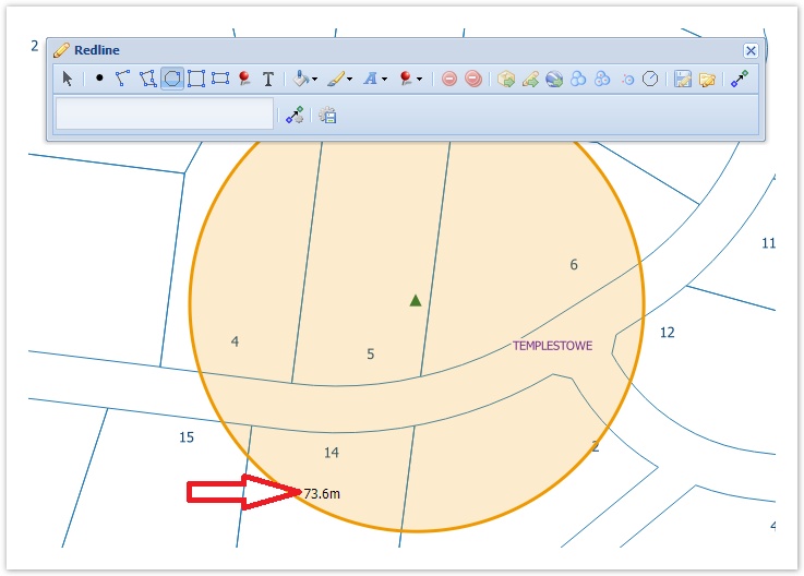
- Drawing a Circle by Radius
It is possible to create a circular buffer of a specified radius using the circleByRadius tool.
For example, the Redline toolbar in your client XML file could look like this:
<item action="weave.redline" multilineLabel="true">
	<tool>save</tool>
	<tool>load</tool>
	<tool>entity</tool>
	<tool action="weave.redline.exportMarkers">
		<defaultProj>EPSG:28355</defaultProj>
		<projection id="EPSG:4283" label="Geographic GDA 1994"/>
		<projection id="EPSG:28355" label="GDA 1994 MGA Zone 55"/>
	</tool>
	<tool>exportKml</tool>
	<tool>buffer</tool>
	<tool>bufferAll</tool>
	<tool>bufferSelected</tool>
	<tool>circleByRadius</tool>
</item>
![]() Searching and Editing
Searching and Editing
- Time fields now support setting the
minvalue,maxvalueandincrementtags. This can be used in the Search and Editing functions. - This has been extended to other field types, where minimum and maximum values and lengths can be set with the following tags:
minvalue, maxvalue, minlength, maxlength, increment. Use the combination of tags that meet your requirements.
	<search:attribute id="sample_point.attr" entity="sample_point" displayname="Sample Point Search" datasource="gis" table="mods.sample_pt" key="id">
        <search:parameter id='type' column='type' promptText="Type" controlType="listbox" dataset="list.poly_type"/>
		<search:parameter id='cost' column='cost' promptText="Cost" controlType="textbox" datatype='integer' maxlength='5' minlength='2' minvalue='20' maxvalue='1000'/>
		<search:parameter id='checkdate' column='checkdate' promptText="Check Date" controlType='textbox' datatype='date'/>
		<search:parameter id='checktime' column='checktime' promptText="Check Time" controlType='textbox' datatype='time' increment='10'/>
    </search:attribute>
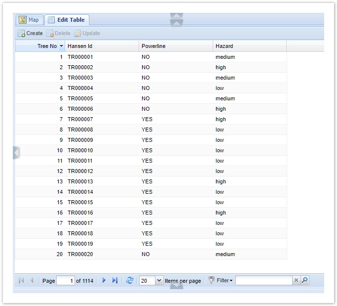
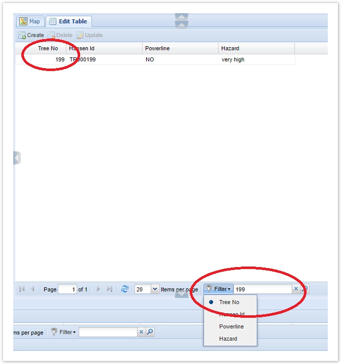
![]() Non-spatial Editing
Non-spatial Editing
- Setting a filter on the grid used for non-spatial editing has now been enabled. This works like the Filter option that is available on the Data Grid.
![]() StreetView
StreetView
- Map View location
- The Weave Map View updates to show StreetView location. So when moving locations in the StreetView tab, the Weave Map View will be updated to reflect this new location.
- The Weave Map View updates to show StreetView location. So when moving locations in the StreetView tab, the Weave Map View will be updated to reflect this new location.
- StreetView Compass
- There were reported cases when the compass on the StreetView tab was not appearing. To overcome this, the compass is now forced to display so should always appear in the StreetView tab.
- StreetView Controls
- More controls have been added for the StreetView tab. The Google Street View API allows more control over what's displayed on the view and where it's displayed and these have now all been exposed in the configuration for the panel. These can be set as shown at the bottom of this Weave wiki page https://cohgawiki.atlassian.net/wiki/x/h4Mx. The result of these settings is shown in the image below, highlighted by red ovals.
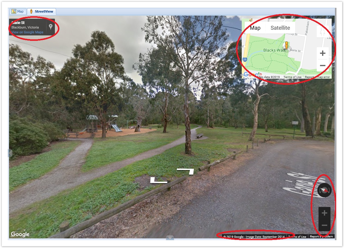
- More controls have been added for the StreetView tab. The Google Street View API allows more control over what's displayed on the view and where it's displayed and these have now all been exposed in the configuration for the panel. These can be set as shown at the bottom of this Weave wiki page https://cohgawiki.atlassian.net/wiki/x/h4Mx. The result of these settings is shown in the image below, highlighted by red ovals.
![]() Zip 'n' Ship
Zip 'n' Ship
- You can now specify a list of entities that can be exported. This can be used to restrict the exporting of layers that might be large, or that you have no authority to be supplying.
<item action="weave.zipnship">
	<entities>
		<entity>property</entity>
		<entity>roads</entity>
	</entities>
</item>
- You can also use this to export a group of entities or a theme as shown in the example below.
<item action="weave.zipnship">
	<tooltip>
		<title>Zip'n'Ship Greenery</title>
		<text>Export selected Tree or Reserve data</text>
	</tooltip>
	<entities>
		<entity>councilreserve</entity>
		<entity>counciltrees</entity>
	</entities>
</item>
![]() Map Tips
Map Tips
- Behaviour
- The behaviour of the Map Tip display has been changed slightly. The tip will now stay on the map if the mouse is in the popup area. This gives a better experience for Map Tip users.
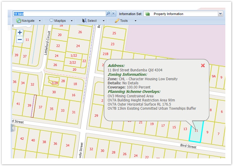
- Map Popup
- There is a new tool that is a variation on the standard Map Tip tool. The Map Popup tool provides the ability to display a map popup when there is exactly one feature selected on the map. The feature could be selected by any supported selection method (i.e. Quick Search, graphical selection, attribute selection, etc.).
- It uses data definitions to supply the data, meaning that the data available to the user can come from any provider, not just the attributes attached to the underlying spatial feature.
- The tip can be displayed using HTML formatting to improve the appearance of the data.
- This new feature is documented in the Weave Configuration Reference.
![]() BIRT
BIRT
- Displaying entries for the current selection can be confusing for some users so there is now an easy way to disable them. At the moment the
removetag can be used but this can now be simplified with theselectionModetag. It is similar toshowMode, will be added with "on" and "off" being the initial options, the default will be "on".
<view id="com.cohga.client.panel.legend" iconCls="">
	<label>Legend</label>
	<location>west</location>
	<remove>planning zones labels, house_numbers</remove>
	<showMode>visible</showMode>
	<extentOnly>true</extentOnly>
	<selectionMode>off</selectionMode>
</view>