Release Notes 2.5.26
2.5.26 had an issue with installation and was immediately replaced by 2.5.27
Weave 2.5.26 includes a number of bug fixes and enhancements.
This release is mostly focused on enhancements and corrections to some of Weave’s most recent tools. The enhancements expand on the functions provided by these tools and also increase the flexibility and usability of some of Weave’s standard tools.
A full list of changes can be found at the Weave What's New page.
The main enhancements in 2.5.26 are:
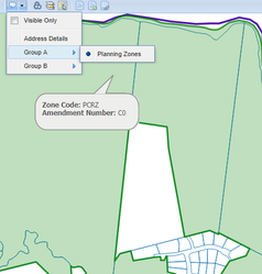
![]() Map Tips
Map Tips
- Geometry
- Map Tips will now show the geometry of the related feature in the default highlight style.
- This is turned on by default and can be turned off by setting
showGeometrytofalsein the Map Tip tool configuration. - If you want to set a different highlight style, use the
highlighttags as per other parts in the client configuration.
- Visibility Flags
- A new
visibleOnlyflag has been added to the tool and individual map tips, to specify that the tips should only be displayed if the layer is turned on in the ToC. The default value isfalse. - There is also
visibleOnlyMenu,which if set totrue,adds a new menu item to the Map Tips menu to allow the user to turn the visible only setting on or off. The default isfalse.
- A new
- Groupings
- Map Tips can be grouped in the Map Tips menu by setting a
groupattribute for the tip. All tips with the same value for thegroupattribute will be included in the same sub-menu, and tips without agroupattribute will appear in the main menu.
- Map Tips can be grouped in the Map Tips menu by setting a
The XML required to implement the four changes shown above (geometry display, visibility flag, visible-only menu and groupings), are shown in the client XML extract below. Also included is an example of setting a different highlight style for Map Tips.
![]() Table of Contents (ToC)
Table of Contents (ToC)
- Context Menu enhancement for
checkAllanduncheckAll- These two items now allow you to set
includeParenttotrueorfalseto change the behaviour of the option with respect to also turning on or off any parent ToC entries. The default setting forcheckAllistrueand foruncheckAllit's false as these would be the most common required behaviours.
- These two items now allow you to set
- Automatically turn on a layer when an entity is selected
- By setting
turnOnActivetotruein the ToC panel Weave will turn on the layer related to the active entity if it's not already turned on.
- By setting
- Index enhancement
- An index search can now be set to turn on the layer with the entity (via the ToC model) by setting
doTurnOnLayertotruefor the index combo in your client configuration.
- An index search can now be set to turn on the layer with the entity (via the ToC model) by setting
![]() Selection Identify
Selection Identify
- There is much more flexibility with this tool now as you can:
- Set it to just search visible layers, by setting
useVisibleEntitiestotruein the tool configuration. - Specify a buffer to use when selecting entities that intersect the selection, by setting
bufferDistance,bufferUnitsandbufferCrsin the tool configuration.- Setting a small negative buffer distance can help report on the correct records when there is a slight spatial overlap between the selected feature and its neighbours as it will stop (or at least reduce) the features being found as overlapping the selected feature.
- Specify a spatial operation to use when selecting entities that "intersect" the selection, by setting
spatialOperationto one ofintersect, contains,oroverlaps. - Specify if the active entity should be included in the search, by setting
includeActivetotruein the tools configuration.
- Set it to just search visible layers, by setting
![]() Spatial Editing
Spatial Editing
- You can now specify a table directly in the edit configuration that should be edited, rather than relying on what's in the spatial mapping for the entity. This should help with editing entities that are spatially backed by a database view.
![]() BIRT
BIRT
- BIRT includes a new North Arrow component that can be added to a report. Add it as you would any other component in a BIRT report.
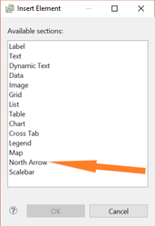
- This is a standard north arrow but means you don't have to load in your own image if you want an north arrow in a report.

![]() Upload File
Upload File
- KML Files
- The KML parser is now more forgiving of invalid KML files that are uploaded so you should be able to load up a broader range of KML files.
- Files that contain label points are supported and will display labels on the Weave Map.
![]() NearMap and Street View Integration
NearMap and Street View Integration
- Reduction of resources used
- The NearMap and Street View panels will not try and retrieve map tiles when the panel is not visible.
- This should reduce your NearMap and Street View data usage significantly.
![]() Database Timeouts
Database Timeouts
- Timeouts added to data definitions
- Database related data definitions now have a server-side timeout, with a default of 120 seconds, to ensure that long-running queries do not keep running.
- You can set the timeout, in milliseconds, in the options for the data definition, or globally as a default, or turn it off completely, using the
timeouttag. - Further details and an example can be found on this wiki page.
![]() Administration
Administration
- Map Engine Refresh
- It is now possible to refresh a Map Engine using
memd resetat the OSGi console or via the Map Engine tool of the Admin Tool. This tells Weave to clear any cached information it may have on a back-end map service and is useful when you change the service and need Weave to take note of the update.
- It is now possible to refresh a Map Engine using
- Map Engine Health Checks
- Health checks have been added for more Map Engine types.
- These can be viewed in the Server Health tool of the Admin Tool.
- Spatial Metadata
- The
spmdcommand (at the OSGi console or via the Console Tool of the Admin Tool) had been updated so that it outputs the count of records when describing a table.
- The
Upgrading
If you need assistance with running a Weave upgrade, refer to this How-to page: How to Run a Weave Software Upgrade.