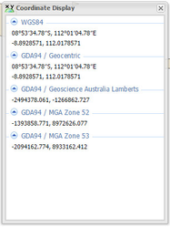
Coordinate Display
- Lucy Minato (Deactivated)
- Graeme Taylor
Description of the tool
This tool displays the coordinates of the mouse location on the Map Window as a geographic value (latitude and longitude), or a measured grid value (easting and northing), in one or more projection systems. The projection systems displayed are set by your Weave System Administrator.
How to use the tool
This tool is accessed via the Coordinate Display button on the main tool bar or from the side panel in the Table of Contents.
Prerequisite:
None
Steps:
- Select the Coordinate Display tool from the main tool bar.

Or open the Coordinate Display tab in the left/right side panel.
As you move the mouse around the Map Window coordinates in the panel will be continuously updated in a range of coordinates systems and projections.
This will either be shown on a separate tab on the left/right panel, the Coordinate Display tab, under the Table of Contents,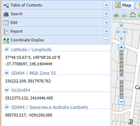
or in a separate Coordinate Display window.
TIP:
You can change the map view by zooming in or out, or panning, when you have the Coordinate Display window open.