Map Panel
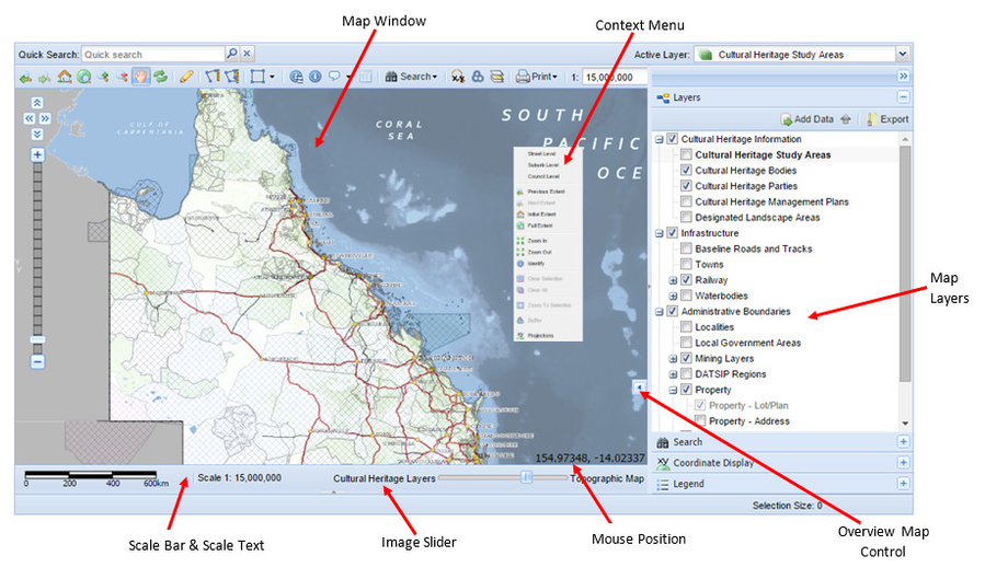
The Map Panel has a number of standard components. These are shown in the image below and described in the table.
| Tool / Function | Description |
|---|---|
| Context Menu (for Map Window) | This is a sub-menu that appears when you right mouse click in the Map Window. It provides a shortcut to a number of Map Navigation tools. |
| Image Slider | This slider bar sets the level of transparency of the background map (e.g. satellite image, aerial photo, topographic map). Moving the slider bar from left to right changes the image from not visible (totally transparent) to completely visible (totally opaque). |
| Map Layers | This shows the list of Map Layers available for display (this panel may be on the left or right of the Map Window) - this is also know as the Table of Contents. The layers may be grouped into themes and these themes can be expanded or collapsed by pressing the + or - icons beside the theme name. Layers and/or themes can be displayed or not displayed on the map window by ticking or unticking the check box beside the layer/group name. |
| Map Window | This is the section of the application where the map will be drawn. |
| Mouse Position | The coordinates of your current mouse position are reflected in the bottom left of the map window. These are in the projection system as defined by your Weave System Administrator. |
| Overview Map Control | This controls the displays of a smaller map that shows you where your main map is in respect to your entire geographic area. The area of your main map is shown by a red dotted rectangle in the Overview Map. The Overview Map is displayed or hidden by pressing the small arrow on the left edge of the Overview Map Control. |
| Scale Bar & Scale Text | The scale of the current Map Window is shown as a Scale Bar and Scale Text. This is updated when the map zoom level is changed through any of the Map Navigation tools. You can select the units for showing map distances in the Scale Bar (Metres, Kilometres, Feet or Miles) by placing the mouse cursor on the Scale Bar and pressing the right button. The units are also scale dependent. |
![]() For details about more functions on the Weave interface, see the Map Layers page.
For details about more functions on the Weave interface, see the Map Layers page.
