Spatial Select
- Lucy Minato (Deactivated)
Owned by Lucy Minato (Deactivated)
Last updated: 13 Jan, 2022
Description of the tool
This tool allows you to select features that based on their spatial relationship with features in a different layer.
How to use the tool
Prerequisite:
A feature has been selected from the map.
Steps:
- One or more features must have already been selected from the map before this tool becomes active.
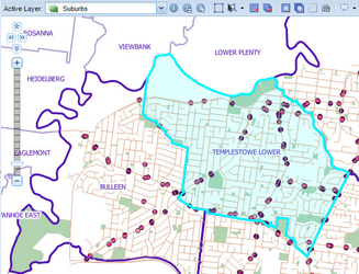
Click on the Spatial Select tool.

- This will display the Selected Entities menu. There are a number of elements to set in this menu:
- Target - This is the name of the Active Layer that features will be selected from.
- Type - This is type of spatial operation to be performed on the Target layer based on the Source layer:
- intersects or touches - Selects all features that fall within or touch the Source (selected) features.
- are within a distance of - Selects all features that are within the given distance of the Source (selected) features.
- is closest to - Selects the features that are closest to (not necessarily touching) the Source (selected) features.
- are next to - Selects the features that are next to (must be touching) the Source (selected) features.
- Source - This is the name of the Active Layer that will be used as the basis for the selection. Only layers that have features selected will be listed in the Source list.
- Distance (m) - Type in the distance (in metres) to be used for the search.
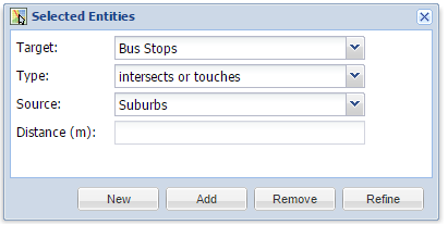
- There are four options for Intersection generation:
- New - This will create a new selection, and will replace any previous selections you had for the Active Layer.
- Add - This will add the selected features to the existing selection set for the Active Layer.
- Remove - The features that result from the Intersect operation will be removed from the selection set for the Active Layer.
- Refine - All but the selected features will be removed from the selection set for the Active Layer.
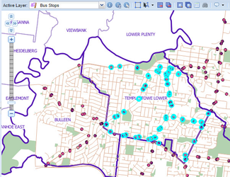
- When you press the New or Add button, a red polygon will be drawn around the selected feature on the map outlining the extent of the features used in the Spatial Select operation. Features from the Target layer that meet the geographic criteria of the Source layer specified will be selected.
, multiple selections available,