Google Earth
- Aaron van Herk
- Peter James
- Graeme Taylor
- Shaun Forbes
NOTE: Google has decided to retire the Google Earth API. Per their deprecation policy, the API will be turned off on December 12, 2015.
http://googlegeodevelopers.blogspot.com.au/2014/12/announcing-deprecation-of-google-earth.html
Cohga is not a registered partner of Google nor is Google associated with Cohga or Weave.
The Cohga developers used the public Google Earth API to create the interface between Weave and Google Earth.
Cohga accepts no responsibility regarding up time or stability of the Google Earth plugin or services relating to it.
The integration between Weave and Google Earth exists via a plugin that must be installed on each client machine. This plugin can be installed via the following URL which requires that the user has the appropriate permissions to install applications on the users machine.
http://www.google.com/intl/en/earth/explore/products/plugin.html
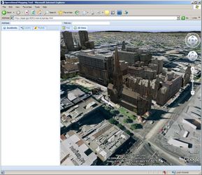
On existing sites it seems to work best with a true 3D model of the area. If just looking at an image on the ground it does not have the same impact. The down side of 3D models is that they generally consume large amounts of memory and consume considerable bandwidth.
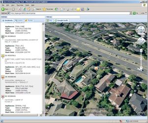
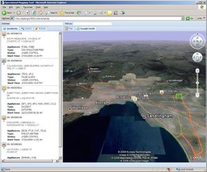
Weave Google Earth Screenshots |
||
|---|---|---|
|
|
|
|
|
|
|
Architecture
The Google Earth Integration has been implemented using the JavaScript API described in the Google documentation. It is designed to reside either in a tab or inside a floating window within the Weave client interface. The Google Earth plugin communicates with the Google servers for the main datasets and with other servers for sourcing KML and images.
There are some artifact issues in some versions of Internet Explorere (IE) when the plugin resides in a floating window.
The plugin and the data that is exposed to Google Earth needs to be considered. Since the Google Earth plugin renderers all content on the client side, it needs to have access to the data sources provided. e.g. any KML dataset needs to be externally accessible for Google Earth to consume it. Depending if the KML source data is intended for both internal and external browsers.
Advantages
- Licensing is still unknown at this stage. Several attempts by Weave sites to contact Google about licensing have not been successful. You can run the Google Earth plugin on external sites however internal use requires that the organisation purchases an Enterprise License.
- Allows visualising 3D data. However Weave does not support exporting 3D data.
- Adds another dimension to the interface.
Disadvantage
- Currently Weave only synchronises the map extent with Google Earth. Move the map to a new location and the the View in Google Earth will update.
- The current map scale is translated into a height above the WGS84 datum in Google Earth. This value is only an approximation and the height in Google Earth may not be exactly the same as the scale in the Map View.
- Currently no way of adding the current selection to the Google Earth view.
- Currently no way for the user to add custom KML URLs to the Google Earth view. The administrator defines what the user sees.
- Browser may suffer memory issues as the Google Earth plugin is memory intensive.
- Only Windows and Macintosh systems are supported.
- Large KML files tend to slow down the browser.
- Data under the ground will not be visible.
- The users computer needs to have a recent graphics card and adequate memory. (See the Google Earth system requirements for more information.)